Odyssey Day 15 - 21

Click on any picture with a border for a larger view

Now for most of my trails you can download my GPS track (bread crumb trail) as well as the map of my track. For more info Click Track Info

-------------------------------------  Day 15 ----------------------------------------------------
   Up and out the motel door at 7:00 AM, temp 21 degrees. We went through a time zone yesterday and now the sun is up when we leave, however there is a mountain just east of us blocking the sun. Like I said this part of the country is flat and then BOING! a mountain, Las Cruces is in the shadow of it. We continue heading west suddenly traffic slowed down and on the east bound side of the highway was a trailer from an 18 wheeler it was bent at a right angle and the side was blown out. It looked like some kind of monster had ripped its way out of the trailer. A mile further down the road, there was another tractor trailer on its side on the west bound lane - apparently we had quite the wind last night.           The rest stops here are quite well maintained and have picturesque picnic tables with sunshades.
   The highway runs parallel to some train tracks where we passed an on-coming train.   I would estimate that the train was going 40 miles an hour east bound. We were headed west bound at 82 miles an hour and I measured the train to be 1.4 miles in length.  Therefore, I estimate the train to be about 1.7 miles long. The train had two layers of sea land containers.
   We crossed the Continental Divide 51.5 miles east of Arizona on highway I-10 at 4,581 foot altitude.
   As I said, it is basically flat with BOING! a mountain sticking up.  Some of the mountains are soft and eroded, and others are fresh and scraggly with many sharp peaks that appear to be volcanic in nature.  (I think the fresh scraggly mountains were volcanic intrusions that never did break the surface and become true volcanoes.  The softer surrounding earth has eroded away leaving behind volcanic rock mountains.)
   Another state line was crossed as we entered Arizona.  Almost immediately we came across vineyards, pecan groves and walnut groves in the middle of the desert!  We saw our first saguaro cactus, a barrel cactus, and agave.  The saguaro, as we got closer to Phoenix became very very numerous.  I had thought they were an endangered species. The agave, I only saw 3 or 4 all day long. The base is a spiky fronds like a yucca top. The agave also has a single stalk about 8 feet high.  The top 2 feet have short, staggered, widely spaced flowers or pods that look to me like leaves.  As for the yuccas, they were everywhere!  Short ones and tall ones. In fact at night with the right lighting, between the yuccas and saguaros you would swear we were being invaded by space monsters. The terrain becomes hillier. And sandstone shows up just like in Moab UT. Sandstone is soft and all corners erode round very quickly.
   “Tucson City limits” is what the sign read. ½ mile later a sign read Tucson 19 miles. (I guess they left room to expand) After Tucson we could see the tails of airplanes off in the distance, lots of them BIG planes. We followed the signs to the “air park” where we were stopped by a guard who explained that an air park is a private maintenance facility for commercial airlines, they do minor to complete rebuilds here and NO tours!  So sat outside the gate and ate our hot-dogs that we cooked on the engine.
   Phoenix - YUP! - a western town, wide roads low buildings and spread out… not up…. like on the east and west coasts. I never would have thought that Phoenix would have so many palm trees, all over. And saguaro and GRAPEFRUIT!  GRAPEFRUIT, orange trees, saguaro and palm trees O’MY!
   Got a room at Apache Junction called Apache Junction Motel.  It will do, as it is only 15 miles to the meeting spot tomorrow at 8:30.

O’ No Mr. Bill saguaro

?

Day 16   APACHE JUNCTION, AZ--------Woodpecker Mine trail

The tie-dye3Tie-dye of saguaro

Rock Art   click picture for full size

Woodpecker mine

Cholla wanabe? with fruit

Cholla with fruit

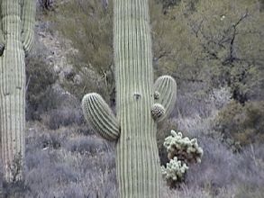
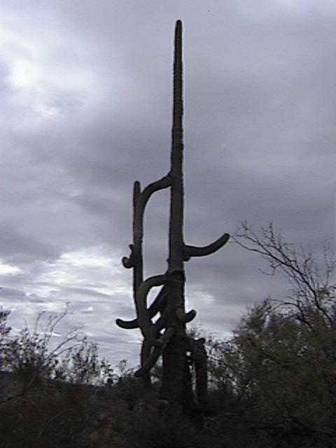
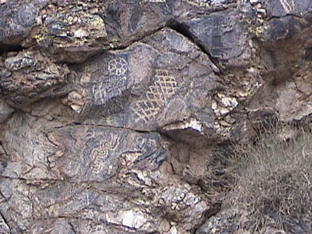
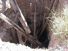
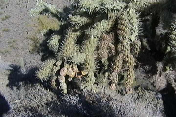
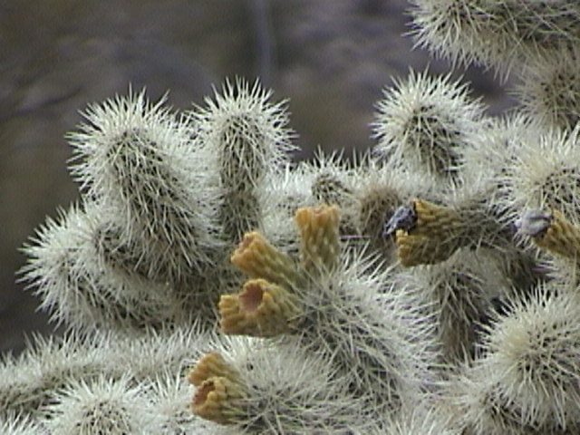
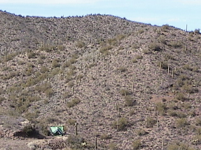
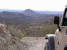
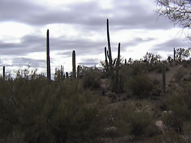
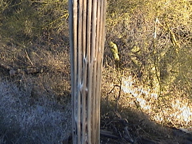
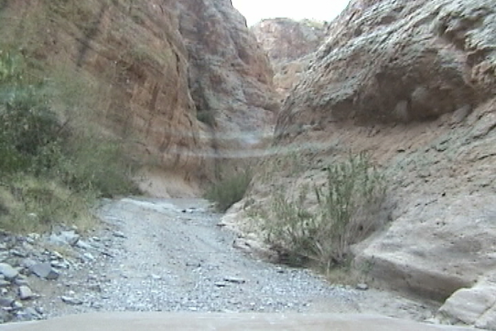
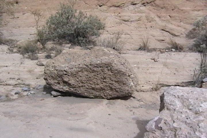
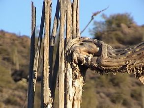
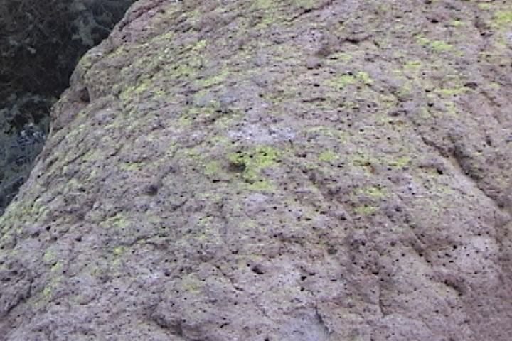
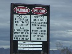
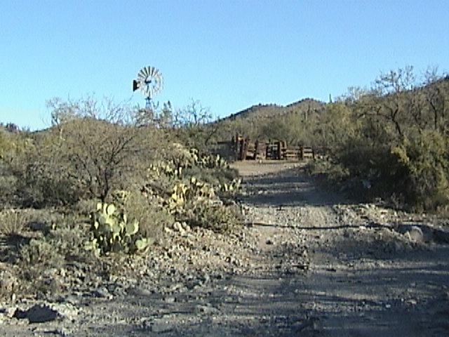
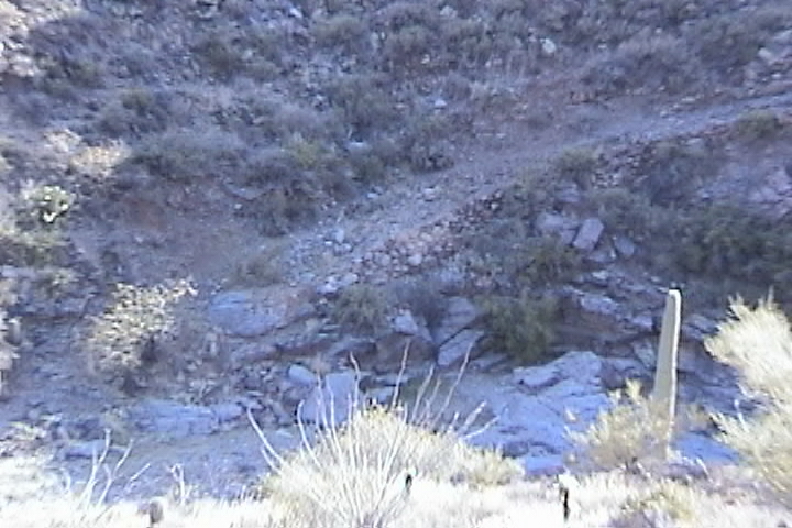
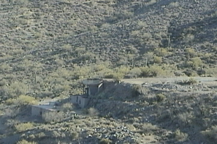
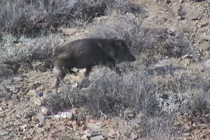
   We left the Apache Motel at 8:08 AM, 52 degrees heading for a Texaco gas station at Florence Jct. to meet up with Mesa 4 Wheelers.  I was told that is the only thing at Florence Jct.  We stop for gas, water and then breakfast at Burger king.  See GPS for coordinates of  Texaco
   There is some confusion on getting to Florence Jct. as my Garman map source has it at the intersection of Rt 89 and Rt 60. While my Rand McNally has it at the intersection of Rt 79 and Rt 60. So after some discussion with my navigator, I headed to the GPS coordinates and arrived at Florence Jct. at 8:38.
   We arrive to find the obligatory repair going on.  There is always one sacrificial jeep being repaired before a group leaves. We aired down and disconnected the sway bars here since the dirt road was only 3 miles away. It is always a great pleasure to meet a group of friendly and outgoing people, it was obvious from the start by the CB banter that many of them had been wheeling together for a long time.  Of our group of 13 we had a diverse bunch, 2 Suzukis, a “it’s not a jeep” Bronco and 10 varieties of jeeps.
   We head out and the first thing I notice is the abundant diversity of the cacti population lots of saguaro, and barrel, cholla, ocotilla, buckhorn, Joshua tree and prickly pear and some even I don’t know! Conspicuously missing which we had seen plenty of before, was the yucca.
   The saguaro are a great cacti they each have a personality. You have the traditional shape all the way to the “tie dye” of saguaro. (see  pictures).
   After a couple of miles we stop lock the hubs and turn up a wash (Woodpecker mine trail). We are headed up a wash it’s in the desert so unless it has rained recently (which it hasn’t) it is going to be a dry rock crawling trail (which it is). There is a tight pass with a boulder climb that just screams got you. Fortunately there is a bypass (on this trail all of the extreme obstacles have bypass and many of the tough obstacles too).  At the first obstacle a jeep got stuck, it turns out because the front ARB was not engaging.  This gave us a chance to admire the Anasazi rock art that was just above the jeep on the rock face.  On the trail repair, (of course it was the same sacrificial jeep from this morning).  45 minutes later we’re on the roll again.
   Since this is a wash it is sandy with occasional rocks and boulders fortunately no waterfalls taller than 18”. I would rate the trail as a 3 (I ran the whole thing open, read that I did NOT engage my locking differentials).  The trail is fun if you like rock crawling (I love rock crawling), not much of a view since you’re in a wash however the cacti alone are worth the trip.
   Not much left of the Woodpecker Mine.  I am told that there are still some hermits working some of the mines! This is where we made camp.
   Cholla cactus has sections that are just slightly smaller than a pickling cuke.  I was told that they break off very easily when touched usually by a passerby whom they stick to and get a ride to a new location.  Being a person who rarely takes things I am told without personal evidence to back it up, I went over to the nearest cholla cactus. Around the base about a dozen of the little sections were lying on the ground (did other people come over and test this theory? Did passing cows or wild life knock them off?  Or did the wind?)  I pushed on one of the sections with my knife.  (I am smart enough not to use my finger).  The section promptly broke off very easily.  (Easy enough in fact that I believe the wind alone could break some of the sections off.)  It fell about 18 inches and stuck into my leather shoe.  After many tries, I was able to fling it off.  I later found out that the needles are barbed (which would explain the difficulty in getting it off my shoe).   And if not removed, like a porcupine quill, will work themselves further in.
   Now this method of reproduction brings up an interesting genetic problem. Have you ever heard of the Irish potato famine?  That happened because to grow potatoes they plant the eyes from last year’s potato (cloning) they had no biodiversity.  So when a blight came, all the potato plants were affected.  If the cholla cactus reproduced by this method, there would be no biodiversity and any kind of disease would run rampant through the cholla population. When the cholla cactus dies it leaves behind a tubular lattice of wood that was its frame.
   Near where we were camped we found a cactus very similar to the cholla.  It had the same wooden lattice framework it had very similar break away sections, except that the needles were thicker and fewer.  The cactus also had more pronounced ribbing. This particular plant had fruit drooping down in clusters.  When I cut into one, the center had small seeds about ¼ the size of a pumpkin seed, similar in shape.  Could this be how the cholla cactus really reproduces and there is a male and female plant?
   I found a cholla cactus with what looked like a little yellow flower.  When I got closer it turned out to be a fruit with a yellow crown. The real reproductive method? Then is the breaking off of sections a defense mechanism? Animals learn not to get near the plant?
 .
   When sunset came we climbed the 10 ft to the top of the mesa set up our chairs and watched a wonderful sunset. The surrounding hills made a natural v-frame for 20 miles of flat land to the mountains the sun was setting behind.  Just to the left of the sun a dozen very bright spots could be seen.  The spots where above the mountains and continued until well after the sun had set.  The spots did slowly change in shape and number, clouds of ice reflecting the sun? … A most unique sunset!  We had a false sunrise,  we woke up to a lot of light outside thinking it was sunrise we opened the tent… between all the stars and the moon it was bright out, you could have read a book!  Did I mention ALL THE STARS!! O well back to sleep

My office in AZ

GPS For Woodpecker Mine trail

Description 

Latitude

Longitude

Meeting spot...  Texaco gas station

N33 15.455

W111 19.954

Turn right onto Mineral Mountain Rd

N33 15.784

W111 16.536

Turn Left up the wash (This is Woodpecker mine trail)

N33 12.032

W111 13.427

Turn right out of wash

N33 12.864

W111 12.193

Woodpecker Mine

N33 12.838

W111 11.816

Turn left to camp

N33 12.842

W111 11.821

Camped for the night

N33 12.920

W111 11.888

Turn right at water tank

N33 12.377

W111 11.578

Windmill working

N33 11.974

W111 12.532

Mineral Mountain Rd

N33 11.855

W111 13.053

DownLoad GPS track info

Day 17--------------------------------


   I do not know what I did but my left shoulder is really painful, I can hardly move it.  Today we stay around camp and work on my web site. I set up a sun shade out of an extra tent fly that I brought along. Unfortunately the sun is so strong that even under the fly the laptop screen gets washed out.   Using clothespins I add a space blanket on top of the fly… that does the trick!
     I get to work for 1 ½ hours before the laptop battery runs down, then I connect a power converter (uses the jeep battery 12 Volt and has a 115 Volt outlet) and hook up the laptop.  Meanwhile I have a 12 Volt cooler that I must run for 20 minutes every hour.  After 3 hours of this routine the power converter alarm for low jeep battery starts to sound every time I move the mouse… then every time I access the hard drive... then all the time, time to run the jeep for 20 minutes to charge the jeep battery. That is how the day went.  Until I lost Saturdays story, the whole day’s story gone!! I hate that, like stapling bologna to your face!
   For dinner I pan fried some beef short ribs, salad coffee. Then off to climb to the top of the butte to watch the sun set. Another great one!

View from the top of Mineral Mt Road

I am standing next to a saguaro
 click picture for full size
Day 18 -------------------------     Box Canyon
 

Saguaro Skeleton

Box canyon

Two different sedimentary rocks in Box canyon

Arm branches off

We are next door to this and yes we got to hear them for most of the night on Sunday!

   If I thought my shoulder hurt yesterday, today I can’t move it. I find it painful to steer the jeep.  To leave, from the Woodpecker Mine continue on down hill, right at the water tank.  Stay on this road.  When you hit the graded road (Mineral Mountain Rd) turn either left for Florence in 21 miles or right to go back to Florence Jct.
   I highly recommend going to Florence as we did.  You will get a marvelous view of the surrounding mountains and a drive through a canyon (Boxwood) not much wider than the jeep.
   As is true with this part of the country every time you go around a corner in the road BOOM a new scenic vista!  This time you could see that the low scrubby hills where we camped were surrounded by large craggy mountains.
   Staying on the graded road we run in and out of a wash.  On the right is a dilapidated building we get out to look it over.  I ran into a couple just leaving it we stop to chat and he says it’s an old stage coach stopover the last one in use in AZ.  I asked “from where to where?” he just shrugged and said “there are a lot of mining towns that no longer exist.”  Both roofs have partially collapsed, tin roofs at that. Did they use tin roofs and stage coaches?  If it was the last working stage coach maybe.
   Eventually you will enter a Y in the road from the top.  The other fork has a lot of traffic on it. The road continues down the wash you are in.. DO NOT TURN HERE!! Continue down the wash. 
   Shortly ~ 0.1 miles after the intersection you will cross a cattle guard… OK get ready now, in about 200 ft the trail gets real narrow with rocks walls that climb way up. Some rocks that litter the canyon flour look like concrete, definitely compressed sediment.  The sides are brownish with a green moss or liken growing on the face and full of pot marks.
   As I said before each of the saguaro cacti have a different personality. I just had to go up to one and play with one (the tie-dye one of course). First I noticed how BIG it was 25 – 30 ft tall with several twisted arms one of which twisted down to where I could reach it. The arm is about a foot in diameter and 8 ft in length. I carefully put my finger between the thorns and pushed, I was really surprised at how firm and rigid it was, it was more rigid than a 2X4!  When I found the resonant frequency and PUSHED I managed to get only about 2 inches of movement on the arm! The supporting skeletal framework of the saguaro is made of woody posts an inch in diameter and formed into the shape of a ring. This is then covered with a juicy pulp a green waxy skin and thorns.  The nutrients are delivered up through the woody posts. I have seen a saguaro cacti with the bottom 2 ft eaten away except for the woody posts (looked like it was on stilts) and still growing just fine!
   When you come out of the canyon which happens fast when you do, the further from the hills you get the thinner the cacti population gets. Turn north east along the RR tracks when you hit pavement turn left.
 I am told (can attest to) there is at least one excellent Mexican restaurant in Florence.  We ate at the L + B. it was quite good, freshly made food. Florence is also the prison capital of AZ with 3 government and 2 private prisons. And one motel, I passed it up. Florence has at least 2 records in AZ
   1. 5th oldest town in AZ
   2. Most historical buildings on the National Register for any town in AZ
   We followed Rt 287 to Casa Grande along the way you will pass Casa Grande Ruins National Monument
 
   At Casa Grande we stayed at Quality inn $71 for one night. Ice and rest for my shoulder.
On one of our many stretch stops my editor came over to me with tears in her eyes, for she had stumbled on a grave marker.  A fairly recent one, with painted white stones it said    MOM    with some flowers and Christmas decorations on some nearby cacti.  Is anybody buried there? At least in spirit!


 What a shame it would be if the tree huggers got this area closed.  Not only would her kids not get to visit the place she apparently loved.  Would this be the last MOM to be able to get here to fall so in love with this place, and want to spend eternity here?
There are ways of protecting areas for future generations, without locking them out!
 
   My navigator thinks it would be an invasion of privacy to put the grave location on the web for the world to see.   I think if the children wanted it secret they would not have marked it so conspicuously with painted rocks and Christmas decorations. But I will err on the side of caution, for once it is put out, the location cannot then be recalled.   

GPS tracks; for Box Canyon from camp at Woodpecker mine.

A working wind mill water pump.  You don’t see many of these working any more. electric easier or did the water table drop to far?

Description

Lat

Long

Turn right Water tank

N33 12.377

W111 11.578

Wind Mill working

N33 10.293

W111 12.214

Left Jtc. Mineral Mountain Rd

N33 11.855

W111 13.053

Overlook

N33 11.150

W111 12.418

Mine

N33 10.293

W111 12.214

Stage Coach stop

N33 09.736

W111 12.149

Head south do not turn “Y” stay on Rd

N33 08.980

W111 12.083

Cattle guard

N33 08.773

W111 12.183

Start of canyon

N33 08.695

W111 12.139

End of canyon

N33 07.842

W111 12.222

Turn right exit wash

N33 06.296

W111 13.266

Turn right to fallow RR tracks

N33 05.803

W111 13.963

Cross RR tracks

N33 05.687

W111 18.050

Cross again

N33 05.606

W111 18.292

Again

N33 04.846

W111 19.204

And just for fun one more time

N33 04.768

W111 20.776

Turn left onto pavement to Florence

N33 03.613

W111 22.745

--------------------------   Day 19 Casa Grande --------------------------------------

   My shoulder is a little better but still very restricted in my available movement.  We went down the road 5 miles to exit 200 and checked out a motel that had an ad on a billboard for $23.95 for 1 we called them up it was $35 for 2. We went to look at it… Lets just say it was the scariest motel I have ever set foot in! We went instead to Motel 6 for 1 more day of ice on the shoulder and rest.

---------------  Day 20 Return to Woodpecker Mine Camp --------------------

   My shoulder is much better.  Leaving the hotel for the backwoods again. We arrived at our previous camp site by re tracing our path up Mineral Mountain Rd  and through Box Canyon. Going in the opposite direction and in the afternoon is a  whole new experience the way the sunlight plays on the canyon

-------------------------------- Day 21 Picketpost Mountain ---------------

Smelting plant

Javelina A nocturnal relative of the wild boar. We saw them at 3:00 in the afternoon.

Day 21
 
   We had a visitor last night. He climbed up the aluminum legs of my table to get at the can! Did he get in? We also heard an owl hoot all night “HOO  HOO”. Spent the day working on my web site. Will be exploring this after noon. Went exploring in the afternoon!
   The roads around here are not tough, any stock 4X4 and with good driving (read that picking a good line) can run on these roads.
   We went for the roads that go up. And up we went, the highest was 3775 ft. (camp is at 2998 ft.) and we found where upper Woodpecker trail comes out.
   We continued to roam, across the wash from us I saw a road, hand made road, like a stone wall. It appeared to bypass a bad spot in the wash for it started in the wash went up around a very rocky spot in the wash (too far below me to see real good) and rejoined the wash. In all about 600 ft long. Shortly after that is the --- mine, and directly across the wash from the mine is a smelting plant or what’s left of it just the concrete parts, the hopper at the top where the raw ore goes in and some concrete platforms (7 of them tiered down the mountain).  I bet the hand made road went to the mine, when the smelting plant was put in I bet they put in the road we’re on (too much traffic for driving up and down a wash especially if it rained).
   We also saw 3 wild boars!  (I later found out that they are Javelinas a cousin to the boar). I was surprised to find them in a desert, they were near the top.  The view from the top was spectacular the green spotted reddish hills surrounded by tall volcanic cores that are left standing when the surrounding land is washed away. Washed away is very apt, for these hills are very steep not rounded. Loose broken up rocks both sedimentary and volcanic rocks mixed together. The volcanic rock is broken, fractured. Anyhoo back to the view, to our north maybe 10 miles, on the slopes of the next mountain chain are some large white buildings. We never did see Phoenix, as it was always behind one hill or another! There where also some excellent examples of yucca and agave cacti. These two plants are similar in format.  A ball of spiky leaves about 3 ft in diameter and a single stalk ~ 12 ft high.  The difference is the agave is a much broader leaf. The thorns remind me of an old time power rip saw. And the flowers on the stalk are tiered on the top 2 ft. Yucca has a much finer leaf and the thorns are more like saw grass.  The stalk is bushy on the top like wheat.
   We turned around just after we went over the pass. ½ mile after we had turned around I heard that distinctive twap-twap that a tire makes when it is flat! Of course I heard it in the middle of a washout and the jeep was precariously perched on two wheels. But yes it was flat. So I continued out of the washout and when I got to leveler ground I tried to fill the tire. That worked so off I drove after 10 minuets I checked the tire it was loosing air not fast- but. So I pumped it up to 40 PSI (see my article on installing a belt driven compressor) and headed back to camp.  I had to fill it up twice more before I reached camp.  At camp I felt around and found a gash in the tire it was just where the tread meets the side wall. It was getting dark so I pumped up the tire and laid 2 flat rocks under the shock mount, that way when the tire goes flat the jeep will rest on the rocks and not the tire. Sitting on a flat tire can cause the tire to pop the bead, then to get air in it you first must re-seat the tire, that requires you to jack up the jeep.  Well 1 hour later I heard a snap and the jeep settled, turned out one of the rocks I had put under the shock mount broke, it was still holding the jeep up, just not as high. I will deal with it in the morning.
 
     For GPS on this trail see Day 23 the day we did the trail to Superior.
Skip to Picketpost second have


[Welcome page]

The Odyssey

[Video, Jeeping 101]

[GPS Track info.]

[Links]

[Odyssey] [Day 8-14] [Day 15 -21] [Day 22 - 28] [Day 29 - 35] [Day 36 - 42] [Day 43 - 49]

[City Match Name] [Name the Folige]

Articlescles

[the shaft] [airing down] [Salsa] [Air Compressor] [Cooking Meatloaf] [Articles in Low-Range]

[City Answers] [Foliage Answers]

[Trails]

[Choke Cherry] [Holy Cross] [Death Valley] [Chili Challenge] [Caballo Mts] [Gila NF Trip] [Titus Canyon]

[Woodpecker Mine]  [Picket Post]  [Box Canyon]

E-mail chris@seetheusabyjeep.com

E-mail Support@seetheusabyjeep.com